|
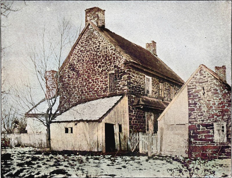
The home of William John. Colorized
photo from 1897.
William John, along
with his cousin Thomas Evan, purchased Gwynedd
Township on March 10, 1698, acting as agents for
"The Gwynedd Company of Friends" who arrived in
July. He owned the upper portion of the township and
lived near the Wissahickon Creek, carving a farm out
of the forest. The house he finished building
in 1712 stood along West Point Pike until the 20th
Century.
Where was his house located?
There is no "William John house" on West point Pike. All evidence of it has been obliterated!
Local historian Edward
Matthews saw
the house in 1907
and
wrote, "It was on the North West side of the turnpike
connecting Morris Road with the Springhouse
Turnpike, a few hundred yards from the toll gate."
In a "local history sketch" published in the Ambler
Gazette, Matthews wrote, "It is situated between
Kneedler and West Point, a half mile northeast from
the latter and on the northwest side of the turnpike
connecting the Morris Road and the Springhouse
Turnpike. A few hundred yards northeast is the
Rhoads tollgate."
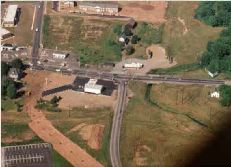
The turnpikes mentioned are known today as West Point Pike
and Sumneytown Pike. There
is no longer a toll gate.
He also said that to
the north was a stone barn, and behind the barn, the
Stony Creek railroad tracks. In front of the house was a
springhouse over a spring, and a meadow. Across the
meadow was the Wissahickon Creek. The spring in all likelihood was the
reason John selected this particular location to settle. A
depression in the ground to the south was the site
of John's log cabin, built around 1700. Matthews
referred to the property as "the former Dannehower
residence". At the time Edwards wrote the
account, the land was owned by J. Wesley Klair.
William John died in
1712, the year the house was completed. In 1747 his
son John Jones sold the area to David Cummings. In
1762 Cummings sold 142 acres to Abraham Dannehower,
a German immigrant. The land stayed in the
Dannehower family for over 100 years, passing to
Abraham's son Henry in 1798, then to Henry's son (also named Henry) in 1825. In 1831 it passed to
Henry's son George Dannehower. George sold it to J.
Wesley Klair in 1897.
According to historian Phil Johnson Ruth, the
William John house was demolished around 1900. Since
Edward Matthews saw the house still standing, it
must have been torn down some time after 1907.
|
|
|
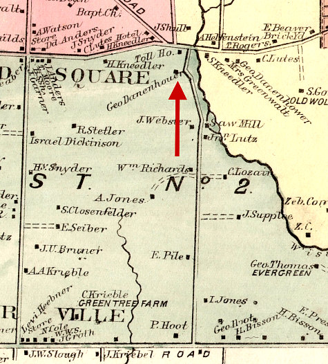
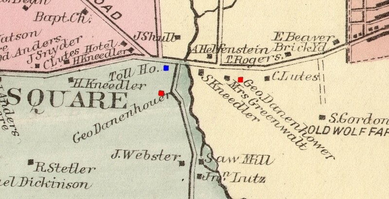
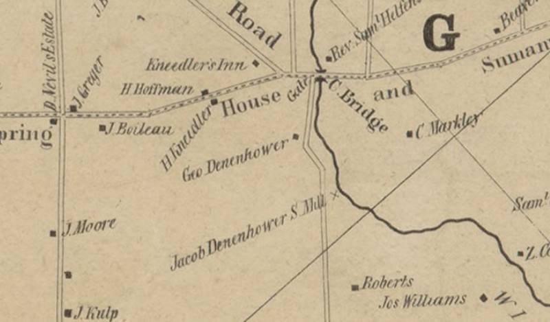
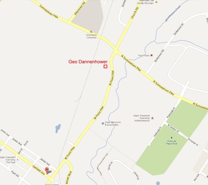
As luck would have it, this map from
1871 shows the George Dannehower residence!
(spelled Danenhouer on the map).
It is
near the toll house, confirming the Matthews
account from 1907. Morris Road is at the bottom, the
"Springhouse
Turnpike" (Sumneytown Pike) is at the top,
and the turnpike connecting the two (West Point
Pike) runs down the middle. |
Thankfully, Matthews
specified which turnpike the house was
on. On this map there is a Geo Danenhouer
and a Geo Danenhower. Matthews spelled the name as
Danenhower, but described the location where
"Danenhouer" is shown on the map. The Toll House is shown
in blue. The road from left to right is the
"Springhouse Turnpike."
The entire map of Gwynedd from 1871 is available here.
(9 megabytes)
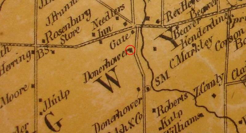
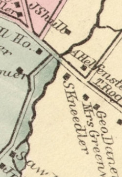
Here's a map from 1877. To add to the
confusion, George's name is now spelled "Donerhower."
There is another Donerhower below the first one,
across from the saw mill ("SM" on the map.)
The entire map of Gwynedd from 1877 is available
here.
(3 megabytes)
We can clear up the confusion with an
even older map. Here, George's name is "Denenhower."
The lower Denenhower is Jacob, and he owns the saw
mill.
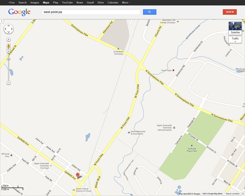
Using a modern Google map,
let's try to find where the sharp bend in West Point Pike was
located. This is where George Dannehower lived, in the
William John house. NOTE: The Pike was moved some time
after 1960 to align it with Church Road.
Taking a piece of the 1871 map, it is copied onto
the modern Google map.
...which gives us this location. We could have done
that with our eyeballs but we're trying to be precise.
| |
|
|
|
|
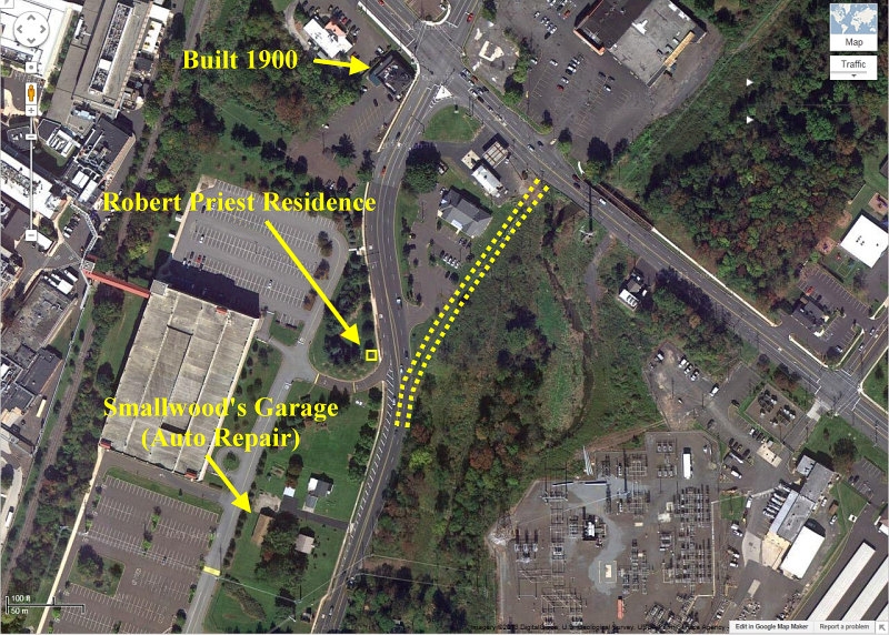
The comments on this map show how the area
looked in 1960, courtesy of one time resident
Stan Welsh. Stan says the bend
in the Pike
wasn't there in 1960, and that the
Priest residence was a three story building
about 100 yards from West Point
Pike.
Merck has
bulldozed the Priest property, but the Smallwood
property remains in the Smallwood family to this
day (2013).
|
|
|
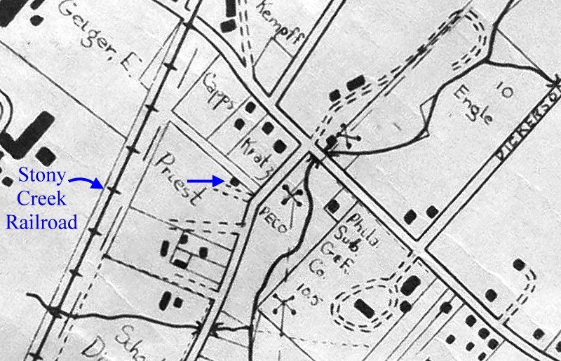
This map from 1954 corroborates
what Stan Welsh wrote about the location of the
Robert Priest property. It seems to be near the
same spot as the
William
John/George Dannehower house. It also
agrees with Edward Morgan's statement about
where the Stony Creek Rail Road was in relation to the
barn.
Just to be clear, the Robert Priest residence
was not the
William
John/George Dannehower house, which had been
razed over 40 years prior.
The sharp bend in the pike on the
1877 map had been straightened and doesn't
appear on the 1954 map. The
entire map 1954 map can be found
here.
|
|
|
|
|
|
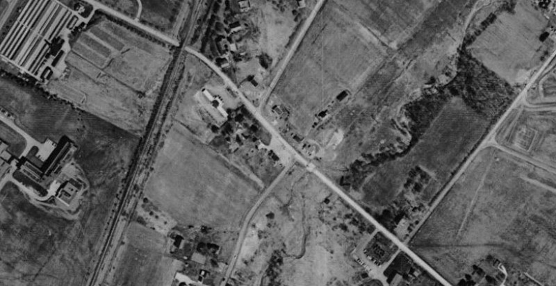
We
have this aerial view of the area taken in 1959. |
|
|
|
|
|
Here is an aerial view of West
Point Pike in the process of being moved.
Sumneytown Pike is through the middle of the
photo, going from left to right. Church Road is
upper-left.. |
|
|
|
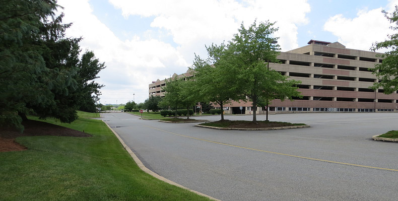
With no real landmarks left, the pike
realigned and then widened repeatedly, and the area completely
bulldozed by
Merck, we can't
derive the exact spot. We can say with
certainty that
William John lived in this immediate
vicinity.
Time for a field trip! |
| |
Our field trip takes us to the area.
It's a nice day, it's actually the 4th of July,
2013.
We walk around and notice this is where West Point Pike ran before
it was moved.
|
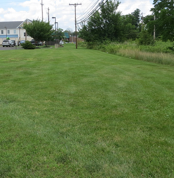
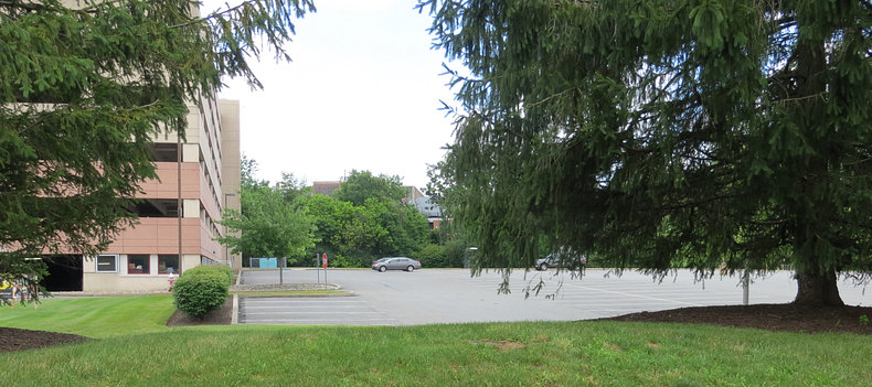
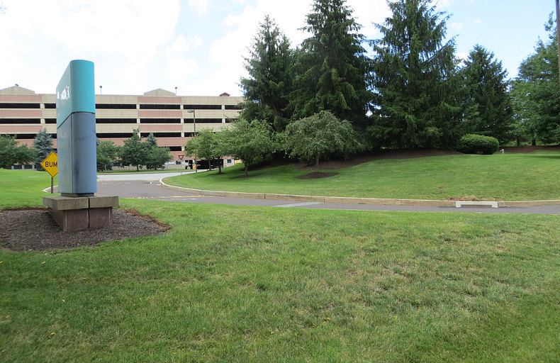
...and somewhere in this scene is the place
where William John lived. It is currently
"Entrance 4" of Merck & Co.
Back here is where the barn would have
been. This view is west, toward West Point.
Looking north, toward the Stony Creek
railroad tracks. (not seen in this picture).
We don't see any cattle or wheat. Or a barn.
|
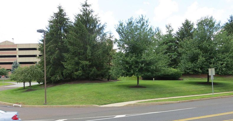
Site of the log cabin and spring house??
Edward Matthews said there was a depression
in the ground where the cabin
had been.
We'll never know where the depression was,
but we guess it was right here or right
nearby. It's all
been bulldozed and landscaped. There's
nothing left. It would be futile to even
search with a metal detector.
|
William John
owned the largest tract of land in Gwynedd,
consisting of 2,866 acres. He
settled a few feet from his southern property line,
close to the border of his nearest neighbor, Evan Ap Hugh, and
near the Maxatawney Trail. (The Maxatawney Trail,
created by the Lenape Indians, evolved into
Sumneytown Pike. The border between the William John
tract and the Evan Ap Hugh tract evolved into West
Point Pike.) It's as though he reached the border,
stepped off the trail, went into the forest a few
feet and stopped. Why did he choose this spot when he
owned so much land? (See this
map.)
Perhaps after
the arduous journey across the Atlantic Ocean, the
labor involved in purchasing the township, and
then by wagon or horseback from Philadelphia, he had
finally arrived at the boundary to his tract and decided to go no
farther. Maybe it was knowing that his family was the
farthest human outpost in the township and there was
nothing to be gained by going farther into the woods
that he chose this spot. Perhaps it was the supply of shale to use
as building material. The
spring was certainly a factor, as Matthews stated.
(The Wissahickon
creek was a few hundred yards to the south but was on Evan Ap
Hugh's land.) The proximity to the trail obviously
made travel easier. It's also possible there was a
meadow here, and the combination of all these
factors made this a good location to carve out a
homestead. We'll never know. William John also owned
322 acres in the lower part of Gwynedd, south-west
of what is called Springhouse, but he chose to
settle in the larger tract.
William John and his wife Jane raised six children
here. In addition to the original log cabin and the
stone house and barn, they had fields of wheat, rye
and oats. They had 21 head of cattle, as well as
sheep, chickens, five horses and "one old mare, with
her brood, in the woods." In the house were two
tables, eight chairs, spinning wheels, rugs, sheets,
blankets, pillow cases and table cloths. The dishes
and pans were of pewter, wood and clay. Naturally,
they would have had all the implements and tools
needed for building a house and barn and running a
farm. Amazingly, only 14 years had elapsed from the
day William John entered Pennsylvania and the day he
died.
Though he has gone down in history, all physical
evidence of William John's life and his home have
been eradicated. If you visit the (now closed)
Sumneytown Tavern or walk along West Point Pike near
the tavern, or drive into "Entrance 4" of Merck, you are where William John once lived.
|